How do winter storms form?
Winter storms derive their energy from the clash of two air masses of different temperatures and moisture levels. Winter storms usually form when an air mass of cold, dry, Canadian air moves south and interacts with a warm, moist air mass moving north from the Gulf of Mexico. The point where these two air masses meet is called a front. If cold air advances and pushes away the warm air, it forms a cold front. When warm air advances, it rides up over the denser, cold air mass to form a warm front. If neither air mass advances, it forms a stationary front.
Click Here to see what winter is like where you live.
How is snow formed?
Snow is commonly formed when water vapor undergoes deposition, which is when water vapor changes directly to ice without first becoming a liquid, high in the atmosphere at a temperature of less than 32°F and then falls to the ground.

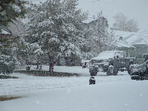
How do blizzards form?
A blizzard is a long-lasting snowstorm with very strong winds and intense snowfall. You need three things to have a blizzard; cold air at the surface, lots of moisture, and lift. Warm air must rise over cold air.
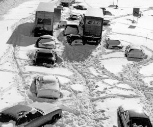
Blizzards can strand cars on highways for hours or even days. When you are traveling during the winter months, be sure to have an emergency car kit in the vehicle with you.
What are snowflakes?
Snowflakes are made of ice crystals. Each snowflake is six-sided and made of as many as 200 ice crystals. Snowflakes form in clouds where the temperature is below freezing. The ice crystals form around tiny bits of dirt that has been carried up into the atmosphere by the wind. As the snow crystals grow, they become heavier and fall toward the ground.

Why is snow white?
Bright snow blinds us with its gleaming white color because it reflects beams of white light. Instead of absorbing light, snow's complex structure prevents the light from shining through its lattice formation. A beam of white sunlight entering a snow bank is so quickly scattered by a zillion ice crystals and air pockets that most of the light comes bouncing right back out of the snow bank. What little sunlight is absorbed by snow is absorbed equally over the wavelengths of visible light thus giving snow its white appearance. So while many natural objects get their blue, red, and yellow colors from absorbing light, snow is stuck with its white color because it reflects light.
What is sleet?
Sleet is just rain drops that freeze into ice pellets before reaching the ground. Sleet usually bounces when hitting a surface and does not stick to objects. However, it can accumulate like snow and cause a hazard to motorists.
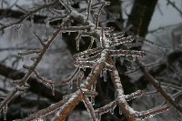
What is freezing rain?
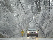
Freezing rain is just rain that falls onto a surface with a temperature below freezing. This causes it to freeze to surfaces, such as trees, cars, and roads, forming a coating or glaze of ice. Even small accumulations of ice can cause a significant hazard.
What is an ice storm?
An ice storm is a type of winter storm caused by freezing rain. The U.S. National Weather Service defines an ice storm as a storm which results in the accumulation of at least 0.25-inch of ice on exposed surfaces.
How do ice storms form?
Ice storms form when a layer of warm air is between two layers of cold air. Frozen precipitation melts while falling into the warm air layer, and then proceeds to refreeze in the cold layer above the ground. This creates freezing rain or a glaze of ice.
What is frost?
Frost is white ice crystals that form on a surface, like the ground or leaves of a plant. Frost is created when the air temperature drops below freezing and the water vapor in the air freezes into ice crystals.
How is lake-effect snow formed?
As the cold air flows over the warm lake water, the relatively warm water heats the air's bottom layer as lake moisture evaporates into the cold air. Since warm air is lighter or less dense than cold air, the heated air rises and begins to cool. As the air cools, the moisture that evaporated into it condenses and forms clouds and snow begins falling from the cloud if the air is humid enough. (Graphic Credit: USA TODAY.)
 |  |
What is a Nor'easter?
Nor'easters can occur in the eastern United States any time between October and April, when moisture and cold air are plentiful. A Nor'easter is named for the winds that blow in from the northeast and drive the storm up the east coast along the Gulf Stream, a band of warm water that lies off the Atlantic coast. They are known for dumping heavy amounts of rain and snow, producing hurricane-force winds, and creating high surfs that cause severe beach erosion and coastal flooding.
What is an Alberta Clipper?
An Alberta clipper is an area of low pressure that generally forms over Alberta, Canada, east of the Rocky Mountains. They develop east of the Rockies because air flowing eastward over the mountains creates favorable conditions. Once an Alberta Clipper forms it usually moves very rapidly to the southeast across the USA's northern Plains and then to the east off the mid-Atlantic Coast. Clippers usually cause only light precipitation with very few producing major snowstorms. However, if conditions are favorable, some Alberta clippers can rapidly intensify off the East Coast once the storm taps the relatively warm moist air over the Atlantic Ocean. The storms that rapidly intensify sometimes spread heavy snow over New England and southeastern Canada. Generally, the main weather features associated with Alberta clippers are some light snow and a reinforcement of cold air over the USA.
What is Wind Chill?
The wind chill is the temperature your body feels when the air temperature is combined with the wind speed. The higher the wind speed the faster exposed areas of your body lose heat and the colder you feel.
Click Here to calculate the Wind Chill.
What is frostbite?
Frostbite is damage to the skin due to prolonged exposure to cold temperatures, usually below 32° F.
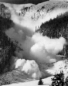
What is an avalanche?
An avalanche is a moving mass of snow that may contain ice, soil, rocks, and uprooted trees. The height of a mountain, the steepness of its slope, and the type of snow lying on it all help determine the likelihood of an avalanche. Avalanches begin when an unstable mass of snow breaks away from a mountainside and moves downhill. The growing river of snow picks up speed as it rushes down the mountain. Avalanches have been known to reach speeds of 245 miles an hour (394 kilometers per hour)—about four times as fast as the speediest downhill skier.

No comments:
Post a Comment