How do meteorologists forecast the weather?
Weather forecasting is a prediction of what the weather will be like in an hour, tomorrow, or next week. Weather forecasting involves a combination of computer models, observations, and a knowledge of trends and patterns. By using these methods, reasonable accurate forecasts can be made up to seven days in advance.
What are weather station symbols?
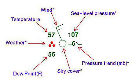
Weather symbols are used on my weather maps as shorthand for the conditions at weather observing stations.
Click Here to see a complete list of all the weather station symbols.
Click Here for an easy print out of the different weather station symbols.
What is a High Pressure System?
A high pressure system is a whirling mass of cool, dry air that generally brings fair weather and light winds. When viewed from above, winds spiral out of a high-pressure center in a clockwise rotation in the Northern Hemisphere. These bring sunny skies. A high pressure system is represented as a big, blue H.
H
What is a Low Pressure System?
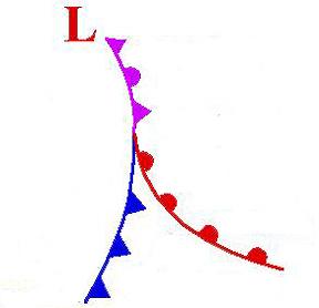
A low pressure system is a whirling mass of warm, moist air that generally brings stormy weather with strong winds. When viewed from above, winds spiral into a low-pressure center in a counterclockwise rotation in the Northern Hemisphere. A low pressure system is represented as a big, red L.
L
What is a front?
A front is a boundary between two different air masses, resulting in stormy weather. A front usually is a line of separation between warm and cold air masses.
What is a cold front?
A cold front is a boundary between two air masses, one cold and the other warm, moving so that the colder air replaces the warmer air. A cold front is represented as a blue line with the teeth pointing toward the direction on movement.

What is a warm front?
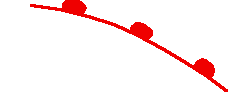
A warm front is a boundary between two air masses, one cool and the other warm, moving so that the warmer air replaces the cooler air. A warm front is represented as a red line with half circles pointing toward the direction on movement.
What is a stationary front?
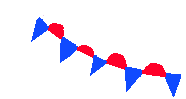
A stationary front is a boundary between two air masses that more or less doesn’t move, but some stationary fronts can wobble back and forth for several hundred miles a day. A stationary front is represented as an alternating warm and cold front symbol.
What is a occluded front?
An occluded front is a combination of two fronts that form when a cold front catches up and overtakes a warm front. An occluded front is represented as a purple line with teeth and half circles.

What is a trough?
A trough on a weather map is an elongated area of relatively low pressure. Troughs bring cloudy and rainy weather. A trough is represented by a hash mark line.
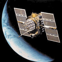
What is a weather satellite?
A weather satellite is a type of satellite that is primarily used to monitor the weather and climate of the Earth. Satellites can be either polar orbiting, seeing the same swath of the Earth every 12 hours, or geostationary, hovering over the same spot on Earth by orbiting over the equator while moving at the speed of the Earth's rotation. These meteorological satellites see more than clouds and cloud systems. City lights, fires, effects of pollution, auroras, sand and dust storms, snow cover, ice mapping, boundaries of ocean currents, energy flows, etc., are other types of environmental information collected using weather satellites.
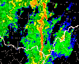
What is radar?
Radar is an electronic instrument, which determines the direction and distance of objects that reflect radio energy back to the radar site. It stands for Radio Detection and Ranging. This is what meteorologists use to see rain or snow.
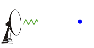
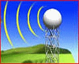
What is Doppler Radar?
Doppler Radar detects precipitation intensity, wind direction and speed, and provides estimates of hail size and rainfall amounts. Doppler Radar gives forecasters the capability of providing early detection of severe thunderstorms that may bring strong damaging winds, large hail, heavy rain, and possibly tornadoes. Combined with satellites, radar gives forecasters the ultimate tools to provide accurate forecasts and advanced severe weather warnings.
How does Doppler Radar work?
Doppler Radar gets its name from the Doppler Effect. Have you ever listened to a train whistle as it was coming toward you? You probably noticed that the pitch of the whistle changed as the train passed you and moved away. This change in the frequency of sound is called the Doppler Effect. Doppler Radar measures the changes in the frequency of the signal it receives to determine the wind.
What is NEXRAD Radar?
The National Weather Service has installed a new type of Doppler Radar called NEXRAD Radar. NEXRAD stands for Next Generation Radar. This radar produces many different views of storms and rain that allows meteorologists to determine if a storm could be severe.

No comments:
Post a Comment